

Overview of Northern Territory space infrastructure
The Northern Territory is already home to globally significant space infrastructure, with more on the way. View the map and list below for an overview of the infrastructure driving development of the space industry in the Territory.
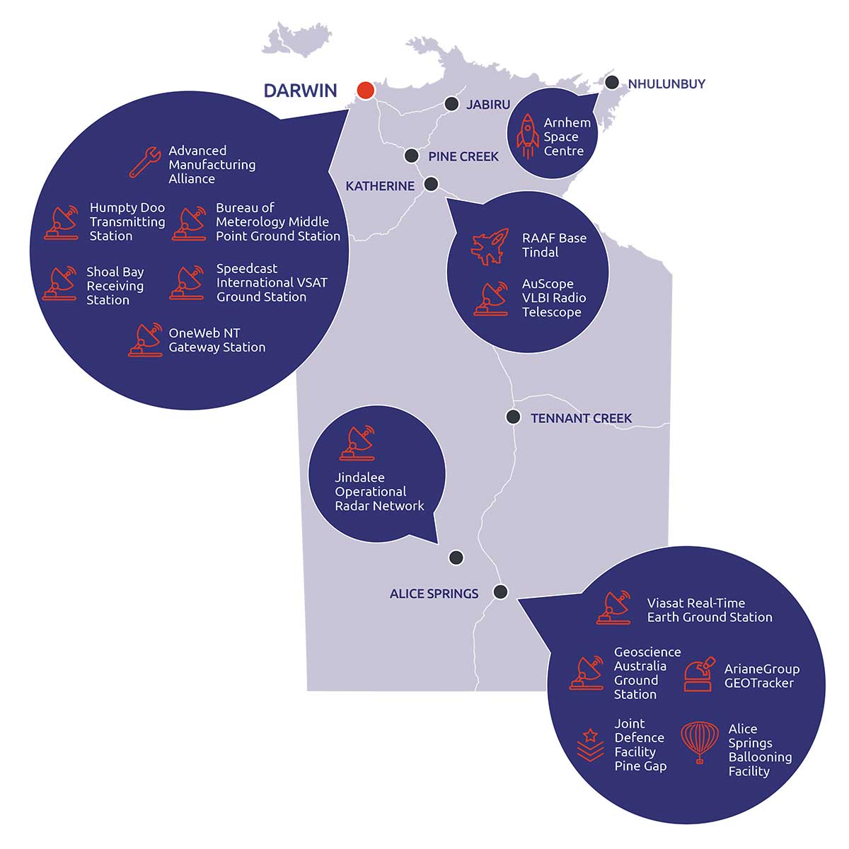
Click on image to enlarge
Equatorial Launch Australia’s commercial launch facility, the Arnhem Space Centre, near Nhulunbuy, is ready to service domestic and international customers from commercial, research and government sectors.
Launch is a crucial component of the domestic and global space economy and has significant potential to spur development throughout the wider national space industry supply chain.
NASA is launching three sounding rockets from the Arnhem Space Centre in June and July this year, its first from a commercial spaceport outside of the US.
Further information
Equatorial Launch Australia
Territory space - truly boundless possible
The alliance is a partnership between Charles Darwin University and SPEE3D to develop world-first 3D metal printing technology and drive collaboration between industry partners, trades and academics.
Internationally, 3D printing technology is already impacting the space industry, from satellite manufacturing to the development of spacecraft components.
SPEE3D has developed a method of printing a previously uneconomic top tier material for rocket engine nozzles - a high strength high temperature copper alloy - that is both low cost and highly efficient. In 2021, the Australian Government’s Modern Manufacturing Initiative awarded SPEE3D a $1.5 million grant, with additional financial support from the Territory Government, to commercialise its technology for the national and international market.
Further information
Advanced Manufacturing Alliance
SPEE3D’s rocket engine manufacturing
The AuScope Very Long Baseline Inferometry (VLBI) array comprises three 12 metre radio telescopes in Katherine (Northern Territory), Mt Pleasant (Tasmania), and Yarragadee (Western Australia).
This network underpins all space based observation, navigation and timing applications in Australia.
The VLBI array is operated by the University of Tasmania, and provides all data to the International VLBI Service, a collaborative body of representatives that operate or support VLBI arrays.
Further information
Geodesy and Geodynamics: measuring and positioning across our continent
International VLBI Service
NASA established the Alice Springs Ballooning Facility in the early 1970s.
Managed by CSIRO and operated by the University of New South Wales, the Ballooning Facility regularly hosts NASA and other international space agencies conducting stratospheric ballooning campaigns.
The space agencies fly stratospheric balloons carrying scientific instruments to the outer edge of earth’s atmosphere to conduct scientific experiments.
Alice Springs was chosen as it offers an ideal vantage point to observe our galaxy, has favourable wind conditions, and its remote location allows for easy recovery of the balloons following their descent to land.
Further information
Read about recent ballooning campaigns on the CSIRO website:
- National Aeronautics and Space Administration (NASA): A partnership as unlimited as space itself
- Japan Aerospace Exploration Agency (JAXA): Japan’s space agency joins us to take near-space balloons up, up, and away
- French Space Agency (CNES): Launching giant space balloons from the centre of Australia.
The Bureau of Meteorology has an extensive network of ground stations with the ability to send and receive signals from satellites. The Middle Point and Shoal Bay ground stations downlink data that is used in the bureau’s weather prediction models.
However, they can also play a role in international space missions. In June 2019, SpaceX launched its Falcon Heavy rocket carrying COSMIC-2 - six satellites with the purpose of improving weather forecasts and space weather monitoring. The Middle Point ground station had a crucial role in this mission, sending command and control information to the satellite.
Further information
The Alice Springs ground station collects earth observation from space (EOS) data from satellites belonging to the United States Landsat network as a result of a 2015 agreement with the United States Geological Survey and NASA.
EOS data is used to shape responses to natural disasters, monitor land use, enhance agriculture management, support water security, and discover new mineral and energy sources.
Geoscience Australia states that in 2015 the total direct benefit from the use and application of EOS data to the Australian economy was $815 million in 2015, and this is expected to rise to $1.33 billion by 2025.
The data is open-access and freely available to government, research and industry users in Australia and around the world.
Further information
In 2021, Territory company Maitec established the North Australian Satellite Validation Facility in Litchfield National Park, approximately 80km south of Darwin, in partnership with ACRI-ST, the European Commission, European and German space agencies, and universities of Southhampton and Valencia.
The site is permanently equipped with a variety of instruments to measure soil moisture and temperature, understorey and canopy cover and leaf area index, with plans to expand this suite further in the near future.
Further information
Speedcast’s Darwin ground station is an important satellite communications network connecting approximately 300 remote sites in the Territory to the internet and Northern Territory Government network.
A number of Northern Territory Government health, education and infrastructure organisations rely on this network for communications and internet needs.
The Centre for Appropriate Technology’s (CfAT) wholly owned commercial subsidiary CfAT Satellite Enterprises partnered with global communications company Viasat on a commercial satellite ground station at CfAT’s Heath Road premises in Alice Springs.
The ground station, owned by CfAT Satellite Enterprises and leased to Viasat, forms part of Viasat’s global Real-Time Earth system providing low-latency, affordable remote sensing satellite data to paying users on demand. It joins a number of similar ground stations that are operating in other parts of the world as part of the network.
Global and domestic customers includes governments and companies across numerous industries including environmental services, shipping, oil and gas, and more.
The commercial arrangement provides another income stream for Aboriginal and Torres Strait Islander-owned CfAT to support its key focus of delivering essential infrastructure to remote Aboriginal communities.
Get in touch with CfAT Satellite Enterprises via the links below to:
- see how you can access data through the Viasat service
- explore opportunities to host your southern hemisphere ground station at CfAT Satellite Enteprises’ Alice Springs facility.
Further information
CfAT Satellite Enterprises website
Viasat partners with the Centre for Appropriate Technology Ltd and Indigenous Business Australia to build a Real-Time Earth ground station in Australia
Give feedback about this page.
Share this page:
URL copied!